![]()
Relieve de las Islas Volcánicas: Erosión, Disolución, Colapso
En 2011 publiqué un artículo sobre la edafogeografía insular en que entre otros archipiélagos se analizaba el de Hawái. Hace unos meses leí una nota de prensa que hacía referencia a otro “paper” cuyo título me pareció sugestivo. Sin embargo, ha resultado ser una trampa (mucho tiempo gastado en vano). Es decir, su contenido es interesante y sorpréndete, por lo que poco os puedo decir al respecto, tras analizar la bibliografía. Mis lecturas sobre el ciclo de vida de los sistemas insulares sobre puntos calientes del manto terrestre hacían énfasis en que la desaparición de las islas se debía más al colapso de los edificios volcánicos, incluidos grandes deslizamientos (generalmente submarinos) de tierras que afectaban porciones enormes de sus respectivos espacios geográficos. Sin embargo, la nota de prensa que acabo de leer y que os muestro abajo, defiende que, al menos en algunos casos, es la erosión la que progresivamente va allanando sus relieves que finalmente terminan sumergidos bajo el océano. No obstante, la originalidad de la isla de hawaiana de Oahu parece estribar en que se ha constatado, mediante estudios geoquímicos, que la disolución de sus rocas que arrastra los materiales disueltos hacia las aguas subterráneas puede ocasionar una pérdida del relieve mayor que la debida a la erosión en sentido estricto (arrastre de materiales hacia el mar por las aguas corrientes, deslizamientos normales, erosión costera, etc.). No había leído jamás nada parecido, más aun cuando gran parte de los materiales de estos archipiélagos son volcánicos y preferentemente basálticos.
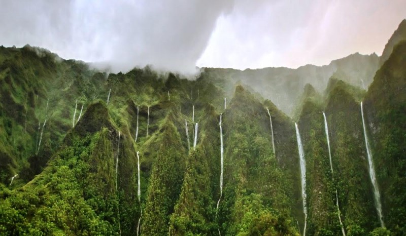
Paisaje de la Isla de Oahu fuente 9Wows
Debe tratarse de la primera evidencia de este tipo de proceso y como corolario, de ser cierto, habría que analizar su singularidad/generalidad en otros sistemas insulares. En consecuencia no me atrevo añadir mucho más al respecto. Abajo os dejo la nota de prensa, fragmentos extraídos de una página Web de la Universidad de Hawái y otro de Wikipedia. Sería sorprendente pero a saber (…). También podéis saber algo más sobre la geología de la Isla de Oahu, y más concretamente su composición geológica, pinchando en las palabras hipervinculadas, como también de lo concerniente a sus aguas subterráneas. Sin embargo, no he encontrado referencia alguna a este proceso.
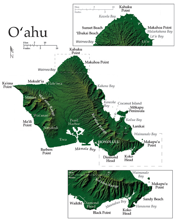
Relieve de la Isla de Oahu: Fuente Universidad de Hawái
Juan José Ibáñez
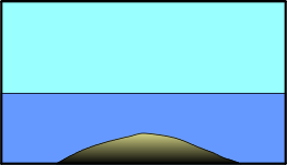
Ciclo de Vida de Una Isla. Fuente: Universidad de Hawái
Hawaiian Islands Are Dissolving from Within, Study Says
Dec. 21, 2012 — Most of us think of soil erosion as the primary force that levels mountains, however geologists have found that Oahu’s mountains are dissolving from within due to groundwater.
Someday, Oahu’s Koolau and Waianae mountains will be reduced to nothing more than a flat, low-lying island like Midway.
But erosion isn’t the biggest culprit. Instead, scientists say, the mountains of Oahu are actually dissolving from within.
«We tried to figure out how fast the island is going away and what the influence of climate is on that rate,» said Brigham Young University geologist Steve Nelson. «More material is dissolving from those islands than what is being carried off through erosion.»
The research pitted groundwater against stream water to see which removed more mineral material. Nelson and his BYU colleagues spent two months sampling both types of sources. In addition, ground and surface water estimates from the U.S. Geological Survey helped them calculate the total quantity of mass that disappeared from the island each year.
«All of the Hawaiian Islands are made of just one kind of rock,» Nelson said. «The weathering rates are variable, too, because rainfall is so variable, so it’s a great natural laboratory.»
Forecasting the island’s future also needs to account for plate tectonics. As Oahu is pushed northwest, the island actually rises in elevation at a slow but steady rate. You’ve heard of mountain climbing; this is a mountain that climbs.
According to the researchers’ estimates, the net effect is that Oahu will continue to grow for as long as 1.5 million years. Beyond that, the force of groundwater will eventually triumph and the island will begin its descent to a low-lying topography.
Undergraduate student Brian Selck co-authored the study, which appears in the journal Geochimica et Cosmochimica Acta. Unfortunately for him, he joined the project only after the field work in Hawaii took place.
Instead, Selck performed the mineralogical analysis of soil samples in the lab back in Provo. The island’s volcanic soil contained at least one surprise in weathered rock called saprolites.
«The main thing that surprised me on the way was the appearance of a large amount of quartz in a saprolite taken from a 1-meter depth,» Selck said.
After he graduates from BYU, Selck will pursue a career in hydrogeology. BYU geology professor David Tingey joins Nelson and Selck as a co-author on the new study.
Story Source: The above story is reprinted from materials provided by Brigham Young University. Note: Materials may be edited for content and length. For further information, please contact the source cited above.
Journal Reference: Stephen T. Nelson, David G. Tingey, Brian Selck. The denudation of ocean islands by ground and surface waters: The effects of climate, soil thickness, and water contact times on Oahu, Hawaii. Geochimica et Cosmochimica Acta, 2013; 103: 276 DOI: 10.1016/j.gca.2012.09.046
Por otro lado, en el siguiente sitio web se nos informa de las siguientes características de la Isla de Oahu, al margen de su composición calcárea (incluyendo formaciones coralinas), basáltica y una geomorfología muy variada.
O‘ahu is the third largest Hawaiian island with 180 km of general coastline that contours a highly irregular shape that was greatly influenced by two massive landslides, that removed ~1/3 of the northeastern portion of the island and aproximately 1/2 of the western side . Today, the shape of O‘ahu is constrained by two great mountain ranges that are the eroded remnants of two separate shields truncated by the prodigious slides.
The Ko‘olau Range (2.7 my in age) runs up the northeast side of the island, perpendicular to the trade winds, whereas the older Wai‘anae Range (3.9 my in age) extends along the west side. Moisture rich trade winds are typically pushed across the broad side of the Ko‘olaus, maintaining lush vegetation that reaches from the mountains to the coast. In contrast, the Wai‘anae Range on the west side is dry, receiving little of the moisture carried by the trade winds.
Geología del Archipiélago Hawaiano según Wikipedia
The chain of islands or archipelago formed as the Pacific plate moved slowly northwestward over a hotspot in the Earth’s mantle at about 32 miles (51 km) per million years. Hence the islands in the northwest of the archipelago are older and typically smaller, due to longer exposure to erosion. The age of the archipelago has been estimated using potassium-argon dating methods.[14] From this study and others,[15][16] it is estimated that the northwestern most island, the Kure Atoll, is the oldest at approximately 28 million years (Ma); while the southeastern most island, Hawaiʻi, is approximately 0.4 Ma (400,000 years). The only active volcanism in the last 200 years has been on the southeastern island, Hawaiʻi, and on the submerged but growing volcano at the extreme southeast, Loʻihi. The Hawaiian Volcano Observatory of the U. S. Geological Survey documents recent volcanic activity and provides images and interpretations of the volcanism.
Almost all magma created in the hotspot has the composition of basalt, and so the Hawaiian volcanoes are constructed almost entirely of this igneous rock and its coarse-grained equivalents, gabbro and diabase. A few igneous rock types with compositions unlike basalt, such as nephelinite, do occur on these islands but are extremely rare. The majority of eruptions in Hawaiʻi are Hawaiian-type eruptions because basaltic magma is relatively fluid compared with magmas typically involved in more explosive eruptions, such as the andesitic magmas that produce some of the spectacular and dangerous eruptions around the margins of the Pacific basin.
Eruptions from the Hawaii hotspot left a trail of underwater mountains across the Pacific over millions of years, called the Emperor Seamounts
Hawaiʻi island (the Big Island) is the biggest and youngest island in the chain, built from five volcanoes. Mauna Loa, comprising over half of the Big Island, is the largest shield volcano on the Earth. The measurement from sea level to summit is more than 2.5 miles (4 km), from sea level to sea floor about 3.1 miles (5 km).
Muy bueno el post, me gustaron las imágenes, saludos